
Fordyce
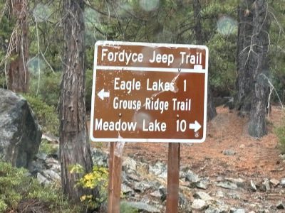
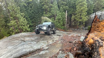
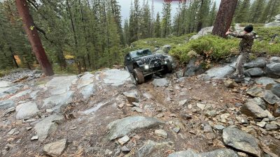
Hidden in the Sierra Nevada Mountains just north of the Rubicon, the Fordyce Creek Trail is one of the most technical and demanding off-road routes in the country. Stretching roughly 12 miles from Eagle Lakes to Meadow Lake, this trail packs everything an experienced wheeler could ask for — boulders, granite ledges, creek crossings, steep climbs, and no easy way out.
If the Rubicon is a badge of honor, Fordyce is a test of mastery. It’s a trail that punishes poor line choice, rewards preparation, and delivers an unforgettable dose of adrenaline with every obstacle.
Trail Overview
-
Location: Near Cisco Grove, California (Placer County)
-
Length: ~12 miles
-
Elevation: 5,500–7,600 feet
-
Difficulty: Extreme — one of California’s hardest official 4×4 routes
-
Open Season: Typically late June through October (depends on snow and water levels)
-
Trail Type: Natural granite terrain, steep ascents, and multiple deep creek crossings
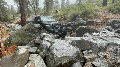
Fordyce Creek runs alongside much of the trail, providing both stunning scenery and serious water challenges. When flows are high, crossings can reach 3+ feet deep — strong winching skills and teamwork are mandatory.
Trail Highlights
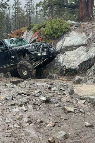
Winch Hills
The Fordyce Trail is defined by its infamous five “Winch Hills” — steep, technical climbs filled with loose rock, off-camber turns, and minimal room for error.
-
Winch Hill 1: A quick wake-up call — traction and throttle control matter here.
-
Winch Hill 3: One of the toughest — steep, rocky, and long.
-
Winch Hill 5: The grand finale — tight, narrow, and unforgiving.
Each hill is a challenge that pushes both driver and machine to their limits.
Creek Crossings
The Fordyce Creek crossings can vary from shallow trickles to chest-deep flows depending on the season.
-
Crossings 1 & 2: Manageable but rocky — good warm-ups.
-
Crossings 3–5: Deep, swift, and often winch-required when flow exceeds 25 CFS (cubic feet per second).
Check water flow levels before you go — the Hydrograph for Fordyce Creek (online) helps gauge conditions.
Granite Playgrounds & Waterfalls
Between obstacles, the trail winds through some of the most scenic mountain terrain in the Sierra. Granite domes, pine forest views, and waterfalls make Fordyce as beautiful as it is brutal.
Vehicle Requirements
This isn’t a trail for the unprepared. To safely complete Fordyce, you’ll need:
-
35”+ tires (37s+ recommended)
-
Lockers front and rear
-
Winch (required by park rules)
-
Skid plates, rock sliders, and recovery points
-
High clearance and solid cooling system
-
At least one recovery vehicle in your group
Pro Tip: If you’ve never broken a part on your rig, Fordyce might change that. Bring spares — u-joints, tie rods, fluids, and tools.
Planning Your Trip
Trail Access Points:
-
Start: Eagle Lakes Road (off I-80 near Cisco Grove)
-
Finish: Meadow Lake (primitive camping and lake views)
-
Length: 8–10 hours depending on group size, experience, and water conditions
Permits & Regulations:
-
No special permit needed, but trail is managed by the Tahoe National Forest
-
Winch and recovery gear required
-
Overnight camping permitted at Meadow Lake (no amenities)
When to Go:
-
Best Months: July–September
-
Avoid: Spring runoff — water levels too high for safe crossings
-
Events: The Sierra Trek (hosted by Cal4Wheel) every August offers guided, supported runs for those tackling Fordyce for the first time
Fordyce Trail vs. Rubicon Trail
| Feature | Fordyce Trail | Rubicon Trail |
|---|---|---|
| Location | North of I-80 near Cisco Grove | Between Georgetown & Lake Tahoe |
| Length | ~12 miles | ~22 miles |
| Difficulty | Extreme | Moderate–Hard |
| Key Obstacles | 5 Winch Hills, deep creek crossings | Little Sluice, Cadillac Hill |
| Crowds | Light to moderate | High, especially summer weekends |
| Water Crossings | 5 deep crossings | Minimal |
| Scenery | Alpine granite, forest, waterfalls | High Sierra granite, lakes, meadows |
| Ideal Vehicle | 37”+ tires, dual lockers, winch | 33”+ tires, lockers recommended |
In short:
If the Rubicon Trail is the classic — the “bucket list” trail that welcomes enthusiasts from around the world — then Fordyce is its rowdier, tougher cousin. The two trails are less than 25 miles apart, both accessible from Highway 50 or I-80, making it entirely possible to tackle Rubicon and Fordyce in the same trip for the ultimate Sierra Nevada off-road experience.
Why Off-Roaders Love Fordyce
Because it’s the kind of trail that earns you bragging rights. There’s no guided route, no easy bypasses, and no cell signal — just granite, grit, and raw adventure.
You’ll test your build, your patience, and your teamwork. You’ll get wet, you’ll get dirty, and if you finish, you’ll join a small group of off-roaders who can truly say: “I wheeled Fordyce and lived to tell about it.”
Ready to test your rig — and yourself — on California’s toughest trail?
Plan your Fordyce Trail wheeling trip today, and experience why off-road veterans call it the ultimate challenge just north of the Rubicon.
